The Earth is filled with breathtaking landscapes, awe-inspiring formations, and natural wonders that captivate the imagination. Behind these marvels lies the powerful force of geography, which shapes the land through processes such as erosion, volcanic activity, tectonic shifts, and the movement of water. From towering mountain ranges to mysterious caves, natural wonders around the world have been sculpted by geographic forces over millions of years. In this article, we will explore how geography has created some of the world’s most astonishing natural wonders and the fascinating facts behind them.
1. The Grand Canyon, USA

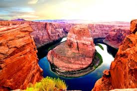
One of the most famous natural wonders in the world, the Grand Canyon in Arizona is a testament to the power of erosion. Over the course of millions of years, the Colorado River carved its way through layers of rock, creating a vast canyon that stretches for 277 miles.
Geographic Facts:
- Age: The Grand Canyon is estimated to be around 5 to 6 million years old. However, the rocks at the bottom of the canyon date back over 1.8 billion years, making them some of the oldest exposed rocks on Earth.
- Depth: The canyon reaches depths of over a mile (6,093 feet) at its deepest point. This impressive depth showcases the layers of rock that have been gradually exposed through erosion.
- Ecosystem Diversity: Due to its vast size and varying elevations, the Grand Canyon hosts a range of ecosystems, from desert conditions at the bottom to coniferous forests at higher elevations.
2. Mount Everest, Nepal/China
Mount Everest, the highest point on Earth, is a product of the powerful forces of plate tectonics. Located in the Himalayas, this towering peak was formed when the Indian tectonic plate collided with the Eurasian plate, pushing the land upwards to create the tallest mountain range in the world.
Geographic Facts:
- Height: Mount Everest stands at an impressive 29,032 feet (8,849 meters) above sea level. However, the mountain continues to grow as the tectonic plates beneath it are still in motion.
- Geology: Everest is primarily composed of sedimentary rock, including limestone and shale, which were once part of the ocean floor. This rock was uplifted by the collision of the tectonic plates.
- Climate Challenges: The extreme altitude of Mount Everest creates a harsh and dangerous environment, with temperatures often dropping below -40°C (-40°F) and wind speeds reaching over 200 miles per hour.
3. The Great Barrier Reef, Australia
The Great Barrier Reef, located off the coast of Queensland, Australia, is the largest coral reef system in the world. Spanning over 1,400 miles, this natural wonder was created by the gradual accumulation of coral over thousands of years, forming a vibrant underwater ecosystem.
Geographic Facts:
- Biodiversity: The Great Barrier Reef is home to over 1,500 species of fish, 400 species of coral, and numerous other marine animals, making it one of the most biodiverse ecosystems on the planet.
- Formation: The reef began forming around 20,000 years ago, during the last Ice Age, when sea levels were much lower. As the ice melted and sea levels rose, coral began to grow on the submerged coastal plains.
- Threats: Rising sea temperatures, pollution, and coral bleaching are significant threats to the Great Barrier Reef, leading to efforts to preserve and protect this fragile ecosystem.
4. Victoria Falls, Zambia/Zimbabwe

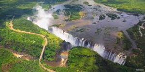
Victoria Falls, located on the border between Zambia and Zimbabwe, is one of the largest and most famous waterfalls in the world. Known as “The Smoke That Thunders” by locals, Victoria Falls was created by the powerful Zambezi River as it carved its way through basalt rock.
Geographic Facts:
- Size: The falls are approximately 1.7 kilometers (1 mile) wide and have a drop of 108 meters (354 feet). During the rainy season, over 500 million liters of water cascade over the edge every minute.
- Erosion: Victoria Falls was formed through a process of erosion, as the Zambezi River gradually wore away the soft rock layers, creating deep gorges and the current waterfall.
- Rainforest: The constant spray from the falls has created a unique rainforest ecosystem along the edges of the gorge, which is home to various plant species and wildlife not found in the surrounding savannah.
5. The Amazon Rainforest, South America
The Amazon Rainforest is the largest tropical rainforest in the world, spanning nine countries in South America. This vast and dense forest was created by a combination of geographic factors, including climate, topography, and the flow of the Amazon River, which shapes the land.
Geographic Facts:
- Size: The Amazon Rainforest covers approximately 5.5 million square kilometers (2.1 million square miles), making it larger than the continental United States.
- Biodiversity: The Amazon is one of the most biodiverse places on Earth, home to over 400 billion individual trees, 16,000 species of plants, and countless animals, including jaguars, sloths, and pink river dolphins.
- River Influence: The Amazon River, which is the second-longest river in the world, plays a crucial role in shaping the rainforest. Its annual flooding deposits nutrient-rich sediments that support the lush vegetation of the forest.
6. The Dead Sea, Jordan/Israel
The Dead Sea, located between Jordan and Israel, is one of the most unique natural wonders in the world. This saltwater lake is situated at the lowest point on Earth’s surface and is known for its extreme salinity, which makes it impossible for most life forms to survive in its waters.
Geographic Facts:
- Lowest Point: The surface of the Dead Sea is about 430 meters (1,411 feet) below sea level, making it the lowest point on the Earth’s surface.
- Salinity: The Dead Sea has a salinity level of over 30%, making it nearly ten times saltier than most oceans. This high salt content allows people to float effortlessly on its surface.
- Geological Formation: The Dead Sea lies in the Jordan Rift Valley, which was formed by the movement of the African and Arabian tectonic plates. The lake is fed by the Jordan River but has no outlet, causing water to evaporate and leave behind salt deposits.
7. The Sahara Desert, North Africa

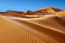
The Sahara Desert, the largest hot desert in the world, spans across North Africa, covering an area of about 9.2 million square kilometers (3.6 million square miles). The Sahara’s vast and arid landscape was shaped by climate changes and wind erosion over millions of years.
Geographic Facts:
- Climate Shifts: The Sahara was not always a desert. Around 10,000 years ago, it was a lush, green region with lakes and rivers. Climate shifts and changes in Earth’s orbit led to the gradual desertification of the region.
- Sand Dunes: The Sahara is famous for its massive sand dunes, some of which can reach heights of over 180 meters (590 feet). These dunes are formed by wind erosion and the accumulation of sand over time.
- Extreme Temperatures: The Sahara experiences some of the hottest temperatures on Earth, with daytime temperatures often exceeding 50°C (122°F). However, nighttime temperatures can plummet to freezing levels due to the lack of humidity.
Conclusion
Geography plays a fundamental role in shaping the natural wonders of our world. From the immense power of rivers carving deep canyons to the slow movement of tectonic plates forming towering mountains, the forces of nature have created some of the most astonishing landscapes on Earth. These natural wonders not only offer breathtaking beauty but also provide valuable insights into the dynamic processes that continue to shape our planet. By understanding the geographic factors behind these wonders, we can deepen our appreciation for the diversity and complexity of the world we live in.

