
Geography is a field that continuously evolves with new discoveries and advancements, unveiling the Earth’s mysteries and reshaping our understanding of its features. Over the past decade, scientific explorations, technological innovations, and field research have led to some truly astonishing geographic discoveries. This article delves into these groundbreaking revelations, highlighting how they have changed our perspective on the planet and its diverse landscapes.
1. The Hidden World Beneath Antarctica
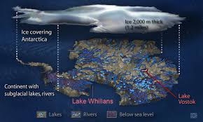
1.1 Discovery of Subglacial Lakes
One of the most significant geographic discoveries of the past decade involves the hidden subglacial lakes beneath Antarctica’s ice sheets. The most notable of these is Lake Whillans, discovered in 2013, which lies under more than 2 kilometers of ice. This discovery was made possible by advanced radar technology that penetrates the ice to reveal these hidden bodies of water. The existence of such lakes, along with others like Lake Vostok and Lake Mercer, has significant implications for understanding glacial dynamics and potential microbial life in extreme environments.
1.2 Ice Loss and Sea Level Rise
In addition to subglacial lakes, researchers have uncovered alarming data regarding ice loss in Antarctica. Studies have shown that the Antarctic ice sheet is losing mass at an accelerated rate, contributing to rising sea levels. The impact of this ice loss is profound, influencing global sea level and climate patterns. Satellite data from NASA’s GRACE mission and other observatories have been crucial in monitoring these changes.
2. The Revelation of the Great Pacific Garbage Patch
2.1 Size and Composition
The Great Pacific Garbage Patch, a massive collection of marine debris in the North Pacific Ocean, has been a focal point of environmental concern. Recent studies have revealed that this floating island of trash is far larger than previously estimated. Research using advanced satellite imaging and oceanic surveys has provided new insights into its size, composition, and movement. The patch is now understood to be a complex mix of plastics, microplastics, and other debris, impacting marine ecosystems and wildlife.
2.2 Efforts to Combat Marine Pollution
In response to this discovery, innovative solutions have been developed to address marine pollution. Organizations like The Ocean Cleanup are using cutting-edge technology to remove plastic waste from the ocean. These efforts are crucial in mitigating the impact of the Great Pacific Garbage Patch on marine life and restoring ocean health.
3. New Insights into the Amazon Rainforest
3.1 Discovery of Uncontacted Indigenous Tribes
In the last decade, researchers have made remarkable discoveries about the Amazon rainforest, including the identification of previously uncontacted indigenous tribes. Using satellite technology and aerial surveys, scientists have located remote communities that have remained isolated from the outside world. These discoveries have heightened awareness of the need to protect indigenous lands and respect their way of life.
3.2 Understanding Deforestation’s Impact
Another significant revelation is the rapid deforestation of the Amazon rainforest and its global implications. Satellite imagery has shown alarming rates of forest loss due to logging, agriculture, and mining. This deforestation not only threatens biodiversity but also contributes to climate change by releasing stored carbon dioxide. Efforts to monitor and combat deforestation are crucial in preserving this vital ecosystem.
4. The Unveiling of Underwater Volcanoes
4.1 Mapping the Ocean Floor
Advancements in underwater exploration technology have led to the discovery of previously unknown underwater volcanoes. The use of deep-sea mapping technologies, such as sonar and remotely operated vehicles (ROVs), has revealed a vast array of volcanic formations on the ocean floor. These discoveries have provided new insights into tectonic processes and the geology of the seabed.
4.2 Impact on Marine Life
Underwater volcanoes play a significant role in shaping marine ecosystems. The release of minerals and gases from these volcanoes can create unique habitats for marine life. Researchers have observed how these volcanic environments support diverse communities of organisms, including those that thrive in extreme conditions.
5. The Formation of New Islands
5.1 Eruption of Hunga Tonga-Hunga Ha’apai
In January 2022, the eruption of the underwater volcano Hunga Tonga-Hunga Ha’apai in the South Pacific resulted in the formation of a new island. This volcanic event created a landmass that emerged from the ocean, briefly altering the geography of the region. The eruption was one of the most powerful in recent history, and the subsequent formation of the island provided scientists with valuable data on volcanic activity and island formation.
5.2 Temporary and Permanent Islands
The discovery of new islands due to volcanic activity highlights the dynamic nature of Earth’s surface. While some of these islands may be short-lived, others can become permanent features of the landscape. The study of these islands offers insights into geological processes and the impact of volcanic activity on the environment.
6. The Mapping of the Mariana Trench
6.1 Exploration of the Deepest Ocean Trench
The Mariana Trench, the deepest part of the world’s oceans, has been the subject of intense exploration over the past decade. Advanced submersibles and remotely operated vehicles have descended to unprecedented depths, providing detailed maps and observations of this extreme environment. The exploration has revealed new species of deep-sea creatures and provided a better understanding of the trench’s geology and ecosystem.
6.2 Discoveries of New Species
Among the discoveries made in the Mariana Trench are previously unknown species adapted to extreme pressure and cold temperatures. These findings have expanded our knowledge of life in the deep ocean and the unique adaptations required for survival in such harsh conditions.
7. The Expansion of Geographic Information Systems (GIS)
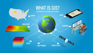
7.1 Advancements in GIS Technology
Geographic Information Systems (GIS) have revolutionized the way we understand and analyze geographic data. Over the last decade, advancements in GIS technology have enabled more detailed mapping and analysis of geographical features. The integration of satellite imagery, remote sensing data, and advanced analytics has enhanced our ability to monitor environmental changes, urban development, and natural disasters.
7.2 Applications in Disaster Management
GIS technology has also played a crucial role in disaster management and response. Real-time data and mapping capabilities allow for more effective coordination of relief efforts and better understanding of the impact of natural disasters. This has been particularly valuable in managing responses to events such as hurricanes, earthquakes, and floods.
Conclusion
The past decade has been marked by astonishing geographic discoveries that have deepened our understanding of the Earth and its dynamic processes. From the hidden lakes beneath Antarctica to the vast expanse of the Great Pacific Garbage Patch, these discoveries have expanded our knowledge and highlighted the need for continued exploration and conservation. As technology advances and our exploration efforts continue, we can expect even more groundbreaking revelations that will further shape our understanding of the planet and its diverse landscapes.