Geography is a field brimming with extraordinary and often perplexing phenomena. From the otherworldly landscapes of salt flats to mysterious holes in the earth, the planet is full of geographical anomalies that defy conventional understanding. This article explores some of the world’s most bizarre geographical anomalies, revealing their unique characteristics and the scientific explanations behind them.
1. The Salar de Uyuni: Bolivia’s Mirror of the Sky

The World’s Largest Salt Flat
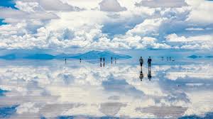
- Overview: The Salar de Uyuni, located in southwest Bolivia, is the largest salt flat in the world, covering over 10,000 square kilometers (3,900 square miles). It was formed from the remnants of a prehistoric lake, Lake Poopó, which dried up over millennia.
- Phenomenon: During the rainy season, a thin layer of water covers the salt flat, creating a reflective surface that mirrors the sky. This stunning effect creates the illusion of walking among the clouds and offers a breathtaking visual experience.
- Scientific Explanation: The salt crust is composed mainly of sodium chloride, with deposits of lithium underneath. The flat’s reflective quality is due to the smoothness of the salt surface and the thin layer of water, which minimizes distortions and enhances the mirror effect.
2. Mount Erebus: The World’s Southernmost Active Volcano
A Fiery Beacon in Antarctica
- Overview: Mount Erebus is located on Ross Island in Antarctica and is the southernmost active volcano on the planet. It stands at approximately 3,794 meters (12,448 feet) high and has been continuously erupting for several decades.
- Phenomenon: The volcano features a persistent lava lake at its summit, which is rare for active volcanoes. The lava lake produces frequent eruptions and gas emissions, creating a continuous display of fiery activity.
- Scientific Explanation: The unique volcanic activity is attributed to the specific tectonic settings and the composition of the magma. The constant lava lake is maintained by the volcano’s underlying magma chamber and the regional geological conditions.
3. The Bermuda Triangle: The Mysterious Sea
A Zone of Disappearing Ships and Aircraft
- Overview: The Bermuda Triangle, also known as the Devil’s Triangle, is a loosely defined area in the western part of the North Atlantic Ocean. It is known for its purportedly high number of unexplained disappearances of ships and aircraft.
- Phenomenon: The area has become infamous due to various legends and theories, ranging from supernatural causes to alien activity. Notable incidents include the disappearance of Flight 19 and the USS Cyclops.
- Scientific Explanation: While many of the supposed mysteries of the Bermuda Triangle have been debunked or explained by natural phenomena, such as rapid changes in weather and ocean currents, the area remains a focal point for conspiracy theories and popular culture.
4. The Eye of the Sahara: A Giant Geologic Formation

A Circular Landmark Visible from Space
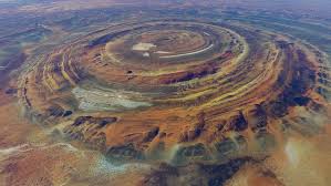
- Overview: The Eye of the Sahara, also known as the Richat Structure, is a prominent circular formation located in the Sahara Desert of Mauritania. It measures approximately 40 kilometers (25 miles) in diameter.
- Phenomenon: The formation’s distinct, concentric rings of rock give it the appearance of an eye from above. It was initially thought to be an impact crater but later identified as an eroded dome.
- Scientific Explanation: The structure is a result of geological uplift and erosion processes. The concentric rings are created by the differential erosion of rock layers, which have been shaped by the region’s climatic and geological conditions.
5. The Door to Hell: Turkmenistan’s Fiery Crater
An Ongoing Fire in the Desert
- Overview: The Door to Hell, or Darvaza Gas Crater, is a natural gas field in Turkmenistan that has been burning continuously since it was ignited in 1969. It is located in the Karakum Desert and has a diameter of approximately 69 meters (226 feet).
- Phenomenon: The crater was created when a Soviet drilling rig accidentally collapsed into an underground cavern filled with natural gas. To prevent the spread of methane gas, the site was set on fire, and it has been burning ever since.
- Scientific Explanation: The crater continues to burn due to the ongoing release of natural gas. The area’s geological conditions and the presence of large underground gas reserves contribute to the perpetual flame.
6. The Great Blue Hole: A Submarine Sinkhole
An Enigmatic Marine Feature
- Overview: The Great Blue Hole is a giant marine sinkhole located near the center of Lighthouse Reef, a small atoll off the coast of Belize. It is approximately 300 meters (984 feet) in diameter and 125 meters (410 feet) deep.
- Phenomenon: The sinkhole is renowned for its striking blue color and its unique geological features. It is a popular site for divers due to its clear waters and the opportunity to explore underwater stalactites and limestone formations.
- Scientific Explanation: The Great Blue Hole was formed during the last Ice Age when sea levels were lower. The sinkhole was originally a limestone cave that collapsed, and over time, seawater flooded the cave, creating the current structure.
7. Socotra Island: The Alien Landscape
A Unique Biodiversity Hotspot
- Overview: Socotra Island, part of Yemen, is known for its unique and otherworldly landscapes. The island is isolated in the Arabian Sea and has developed a distinctive flora and fauna not found anywhere else on Earth.
- Phenomenon: The island is home to bizarre plant species, such as the dragon’s blood tree with its umbrella-shaped canopy and red sap, and the bizarre-looking bottle tree. Socotra’s isolation has led to high levels of endemism and evolutionary divergence.
- Scientific Explanation: Socotra’s isolation and diverse microclimates have contributed to the development of its unique ecosystems. The island’s geological history and climatic conditions have allowed for the evolution of plants and animals adapted to its distinct environment.
8. The Floating Islands of Lake Titicaca

Man-Made Islands in the Andes
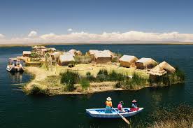
- Overview: Lake Titicaca, located on the border between Peru and Bolivia, is home to the Uros people who have constructed floating islands using reeds. These islands are made from totora reeds, which are abundant in the lake.
- Phenomenon: The Uros have built these floating islands as a way to escape from hostile neighbors and to adapt to the lake’s conditions. Each island is anchored to the lakebed with ropes, and new reeds are added regularly to maintain the islands’ buoyancy.
- Scientific Explanation: The floating islands are constructed using layers of reed roots and reeds, which are buoyant and provide a stable platform. The technique has been used by the Uros for centuries and is a testament to their ingenuity and adaptation to their environment.
Conclusion
The world is full of geographical anomalies that challenge our understanding and spark our curiosity. From the reflective mirror of the Salar de Uyuni to the fiery Door to Hell, these anomalies offer a glimpse into the planet’s diverse and extraordinary features. Each anomaly has its own unique story, shaped by natural forces, historical events, and human ingenuity. Exploring these wonders not only enhances our knowledge of the Earth’s geology and geography but also inspires awe and wonder at the remarkable phenomena that define our world

